Not all acres are equal in Los Altos Hills. Two parcels can share the same lot size and produce very different outcomes when you try to build, enjoy a yard, or plan a driveway. If you’re comparing properties or preparing to sell, you want to understand how the market converts gross acreage into usable value. This guide breaks down what “usable flat land” really means, how appraisers and buyers evaluate it, and the steps you can take to price or purchase with confidence. Let’s dive in.
What “usable land” means in Los Altos Hills
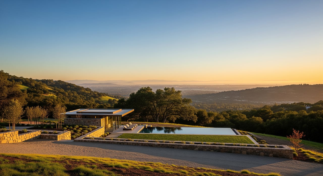
Los Altos Hills is known for large lots, semi-rural character, and hillside terrain. That terrain is beautiful, but it also means the market focuses less on the total acreage and more on the part you can actually use.
- Gross acreage is the full parcel area recorded on the deed or assessor’s roll.
- Usable acreage is the portion you can realistically develop after you account for slope, setbacks, easements, trees, environmental constraints, access, and utilities.
- A building circle (or building envelope) is the contiguous flat or gently sloped area that can accommodate your home footprint, driveway, septic or well if needed, and required setbacks.
Because Los Altos Hills has strict hillside controls and in some areas relies on private wells and septic systems, small differences in site usability can have a large price impact. Buyers are effectively paying for the building circle and the site conditions that make it feasible.
Why slope and site drive price
Topography and slope
Steeper lots often have a smaller contiguous area for a home, outdoor living, and a workable driveway. They can also require more grading and retaining, which adds cost and time. Buyers and appraisers discount for steep terrain when it limits the building circle or raises construction complexity.
Soils and geotechnical conditions
Soil type, depth to bedrock, expansive clays, and groundwater affect foundation design and grading. If a site needs deep foundations or rock excavation, development costs rise and value falls. A preliminary geotechnical review is a common early step to reduce uncertainty.
Access and driveway feasibility
Legal and physical access matter. Gentle, short driveways from paved roads are easier and cheaper to build. Long, steep, or switchback driveways require engineering, drainage, and may trigger emergency access standards, which reduce market value relative to easy-access parcels.
Utilities, septic, and water
Connection to municipal water and sewer improves feasibility and financing. In areas without sewer, a septic percolation test becomes critical. Lots without clear utility solutions face buyer pushback and price discounts to offset risk and complexity.
Environmental and tree constraints
Protected habitat, riparian areas, and heritage or protected trees can limit clearing and building envelopes. If removal or mitigation is required, it reduces usable acreage or adds costs, which the market prices in.
Fire risk and emergency access
Los Altos Hills includes areas with elevated wildfire risk. Defensible space, road widths, turnarounds, and vegetation management influence site planning and cost. Insurance availability and premiums also affect buyer demand and pricing.
Zoning, setbacks, and floor area limits
Local zoning and hillside standards govern setbacks, height, lot coverage, and sometimes maximum floor area. Strict rules can reduce your feasible footprint and increase entitlement complexity, which lowers value versus less constrained lots.
Easements and recorded restrictions
Utility or access easements, open-space restrictions, or private covenants can cut into your buildable area. An easement that crosses the logical building circle can significantly reduce effective value even if gross acreage is large.
Permitting risk and time to build
Long entitlement timelines, uncertain approvals, and special permits for grading or tree removal add carrying costs and risk. Buyers discount for time and uncertainty, especially if discretionary approvals or variances seem likely.
How appraisers and buyers value usable area
Focus on the building circle
Appraisers and buyers focus on what the parcel can support at its highest and best use, which is typically a single-family residence. A flat or gently sloped building circle that fits the planned home, access, and required systems is the starting point for value.
Comparable sales the right way
The best comps share similar usable building envelopes, access conditions, utility status, terrain, and view potential, not just similar gross acreage. A two-acre lot with a small flat pad is not directly comparable to a two-acre flat lot.
Adjustments that move price
- Access and driveway: Steep or long access routes reduce price due to construction and maintenance obligations.
- View premium: Unobstructed valley or scenic views can command strong premiums. Partial or blocked views reduce that premium.
- Utilities: Ready sewer and water improve marketability; reliance on septic or wells introduces feasibility risk and a discount.
- Entitlement complexity: If extra approvals seem likely, buyers apply a risk discount.
- Buyer type: Developers price in higher costs and risk margins. Owner-builders may pay more for a site that fits a specific vision.
Cost-to-create-the-pad check
When close comps are scarce, buyers often estimate the cost to create the flat pad, driveway, and utility connections, then back into land value. If it takes significant grading, retaining, or access work to achieve the same usability as a flat lot, the land price adjusts downward.
Seller playbook: present usability, protect value
Sellers win when they document usability up front. You help buyers see the building circle and reduce their perceived risk.
- Commission a recent topographic and boundary survey.
- Gather a preliminary geotechnical letter and any soils borings you have.
- If sewer is unavailable, provide current septic percolation test results or proof of feasibility.
- Confirm utility serviceability and easements with current letters.
- Assemble a clean title report showing all easements and restrictions.
- Document any prior permits, grading plans, and as-builts.
- Include arborist or environmental reports if tree or habitat issues are likely.
Use this documentation to position your property by usable acreage, not gross acreage. You set accurate expectations and reduce discounting for unknowns.
Buyer playbook: evaluate before you offer
If you are shopping in Los Altos Hills, prioritize feasibility and risk reduction early. Build your team and validate the building circle before you bid.
- Engage a licensed surveyor for a current topo and boundary survey.
- Consult a civil engineer on grading, drainage, and driveway design.
- Order a preliminary geotechnical review; expand to a full report if warranted.
- Verify utilities and, if needed, complete a septic perc test.
- Have an arborist or environmental consultant review tree and habitat constraints.
- Ask a planning consultant or attorney to review title, easements, and entitlement risk.
- Work with a local agent who knows hillside comps and active buyer preferences.
Add contingencies for geotechnical and percolation results, utility feasibility, and access easements. Price in the time and cost to obtain approvals and to build the pad and driveway.
Quick checklist: documents and experts
Documents to collect
- Recorded deed and parcel map
- Current title report with easements
- Topographic and boundary surveys
- Geotechnical reports or scoping letter
- Septic perc results or sewer feasibility letter
- Utility serviceability letters
- Arborist and environmental studies
- Prior permits, grading plans, as-builts
- Road maintenance agreements or HOA documents if access is private
Professionals to consult
- Licensed surveyor
- Civil/site engineer
- Geotechnical engineer
- Arborist and environmental consultant
- Planning consultant or land-use attorney
- Architect with hillside design experience
- Local Los Altos Hills real estate agent
Red flags to surface early
- No legal access or unresolved easement issues
- Conservation or open-space restrictions over likely building areas
- Mapped landslide activity or known instability
- No feasible septic or well solution and no municipal alternative
- Infeasible driveway due to slope or emergency access requirements
- Excessive cost or risk of denial tied to grading or hillside rules
Where to verify rules and data
Cross-check site assumptions with authoritative sources to avoid surprises:
- Town of Los Altos Hills Planning Department for zoning, setbacks, hillside, grading, and tree rules.
- Santa Clara County Environmental Health for septic and percolation requirements.
- County Assessor and Recorder for parcel data, deeds, and easements.
- CalFire for Fire Hazard Severity Zone mapping and defensible space guidance.
- California Geological Survey for landslide and seismic hazard mapping.
Final thoughts
In Los Altos Hills, buyers pay for the land they can confidently use. A smaller flat building circle on a larger steep lot can be worth far more per square foot than the surrounding slope, while a truly flat lot often trades at a premium. If you are selling, lead with documentation that proves usability. If you are buying, focus on feasibility first and comps that match the building envelope, not just the gross acreage.
If you want a tailored read on your property or a short list of site experts, connect with Straser Silicon Valley to walk through your options and timing. Request a white‑glove consultation.
FAQs
How does slope affect pricing in Los Altos Hills?
- The market discounts for lost contiguous building area and higher construction complexity. Buyers value the usable building circle far more than steep, non-buildable acreage.
Why is a septic percolation test so important if there’s no sewer?
- Without a successful perc test, a lot may be undevelopable or require costly alternatives. Buyers often make offers contingent on perc results to reduce risk.
Do superior views offset a steep site?
- Often yes. Strong, unobstructed views can command premiums that help counter slope-related discounts, but the actual premium depends on view quality and whether it is likely to remain.
How do appraisers pick comps for hillside lots?
- They prioritize parcels with similar usable building envelopes, access conditions, view exposure, and utility status rather than matching gross acreage alone.
What documents should I assemble before listing a hillside lot?
- A current topographic and boundary survey, title report with easements, geotechnical findings, septic perc results or sewer feasibility, utility letters, prior permits, and any arborist or environmental studies.